
Trace a Kearny Street by Address
A Kearny street directory search starts by normalizing the address. Keep the house number, street name, suffix, unit if known, postal city, ZIP, municipality, county, and search date separate. The physical address, the tax parcel, the postal delivery label, and a historic directory address are not interchangeable. The parcel-first route is especially useful when an old street number or a missing owner field makes a name search weak. NJGIS can supply a municipal parcel key, while the Kearny Assessor can route a request for a property record card, tax map, assessment history, subdivision information, inspection information, or a current-owner entry.
Use the same address and date across each source. A map result does not establish present occupancy, and a deed party does not prove that the party lived at the conveyed property. The Kearny street directory is a record trail, not one all-purpose list.
- Search the address in the NJGIS Property Explorer and record the municipality, block, lot, and any parcel identifier shown.
- Open the Hudson County GIS Hub, locate the parcel, and save the map layer and date with the result.
- Ask the Kearny Tax Assessor about the property card or tax map when the public map does not answer the address question.
- Use the block, lot, municipality, or address in the Hudson County Register's Acclaim index, then preserve each instrument reference.
- For an earlier household question, compare the date-specific number with the Kearny Library Street Guide and directory sections.
Note: Keep a result's access date and source role because a map, an assessment card, a deed, and a directory each describe a different point in time.
Kearny Street Directory Parcel Fields
The state parcel route is the clearest public starting point for a Kearny address. NJGIS Property Explorer accepts an address, county, municipality, block, or lot. Its parcel data represents municipal tax lots, and its PAMS identifier combines county, municipality, block, lot, and qualification components. A map click can still reveal a block and lot when a name does not appear. The Hudson GIS Hub is useful for map and data discovery, but the inspected sources did not establish an exact Kearny public application or complete layer dictionary. Treat the map as a way to identify land, then reconcile it with the Assessor and Register.
Hosted owner data can be redacted under Daniel's Law. A blank name beside a parcel is not a reason to guess or to seek around a protected address. County edges may also fail to line up perfectly in parcel data, so a property near an edge should be checked against the state layer and the correct municipality.
| NJGIS field | Use for a Kearny address | Format or caution |
|---|---|---|
| Address | Locate a parcel by street number and name | Exact normalization behavior was not located |
| County | Narrow the search to Hudson | Optional selector |
| Municipality | Retain Kearny as the municipal label | Optional selector |
| Block and lot | Carry the tax-map key into other records | Format and qualification handling were not located |
| Parcel or PAMS identifier | Link map, assessment, and Register research | Input behavior was not verified |
| Map click and GIS layer | Select a parcel and note the visible layer | Available layers vary |
The Kearny street directory gains precision when the current municipal block and lot remain attached to an old address. That key can survive a changed street label better than a name alone.
Kearny Address Records at the Assessor
The Kearny Assessor maintains tax maps, property record cards, new-owner records, subdivisions, assessment changes, tax abatements and exemptions, pre-construction estimates, inspections, and changes associated with demolition or fire. Those duties make the office a practical address custodian. The official page did not expose a public owner-name search URL or a verified public form-field set. Use the office route or an OPRA request instead of claiming an online Kearny street directory entry that the research did not locate.
When asking about a releasable card, describe the property and the record needed. Useful request targets include the displayed owner name, mailing and situs addresses, block, lot, qualification, assessment values, tax year, map reference, sale or transfer date, and source or update date. These are request targets, not a verified live Kearny card schema. A mailing address can differ from the situs address, and an assessment field should be dated before it is used as historical evidence.
Kearny Tax Assessor
Official assessment information describes maps, cards, ownership updates, subdivisions, and assessment work. Ask the office which records are currently releasable for the parcel.
Kearny Finance Department
Municipal finance information covers tax collection and the annual tax-sale process. A tax-sale notice is not itself proof of a completed conveyance.
Kearny Street Directory Deed Searches
The Hudson County Acclaim Official Records Search is the recorded-land route for a Kearny street directory search. It offers name searching for grantor or grantee, book/page searching by book type, number, and page, an instrument number field, and a Legal Description route for lot, block, municipality, or address. It also lists document type, consideration lower and upper amounts, and record date. The legal-description route is valuable when parcel data does not display an owner name.
Start with the current block and lot or a known instrument. Then compare the result's legal description, document type, record date, book/page, instrument number, grantor, and grantee. Acclaim advises spelling variants and states that accuracy is not guaranteed. Its official material does not state the earliest online index or image date. When a record does not appear online, the Hudson County Register says computerized and hard-copy property indexes are available. Ask about earlier paper books, microfilm, or a missing-image procedure rather than concluding the instrument never existed.
New Jersey's house-history research sequence reinforces the order of parcel, deed, tax and map evidence, directories, census, newspapers, photographs, and local archives.
The guide is useful for a Kearny address because it keeps land evidence and household evidence in separate parts of one documented trail.
Kearny Street Numbers Need Context
A current house number is not enough to prove that an older Kearny directory entry refers to the same building. The municipal code includes an application for a correct house number, but the research did not locate a public historic renumbering project or a year-specific renumbering list. For a disputed number, ask the municipal code or planning office whether it holds a number assignment, road-opening permit, certificate, or historic record. Keep former numbers, current numbers, street suffixes, municipal place names, and block/lot together.
The issue is also historical. Before Kearny Township was created from Harrison Township in 1867, relevant records can use Harrison and the county context in effect at the time. Kearny became a town in 1899. The Library's historic volumes may group Harrison, Kearny, Arlington, East Newark, and North Arlington without making those labels modern boundaries.
Kearny Code Chapter 14 provides the official house-numbering reference used when reconciling a modern number with an address record.
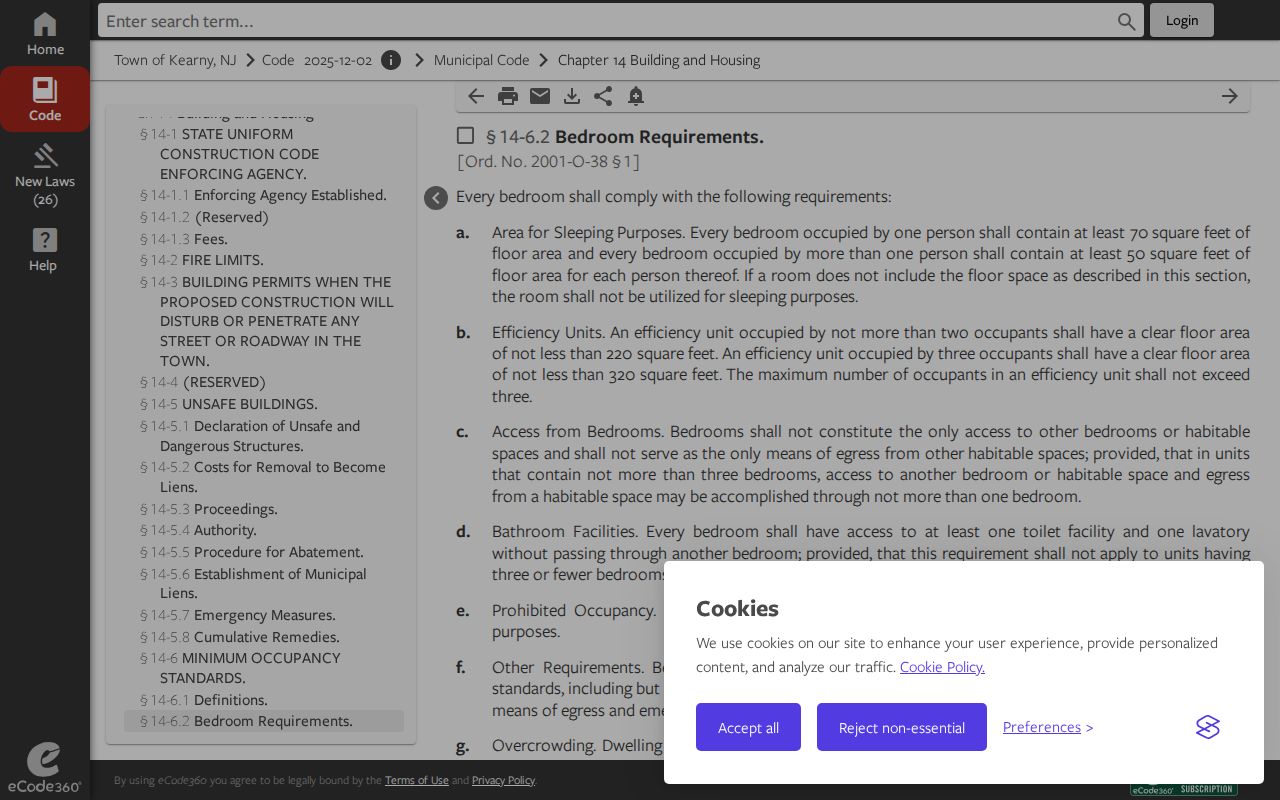
Use the code as a current numbering authority, then test historical continuity through a street guide, parcel description, deed, and map rather than relying on one result.
- Parcel
- A mapped municipal tax lot, usually identified by a block and lot.
- Situs address
- The physical location attached to a property record; it can differ from an owner's mailing address.
- Plat
- A recorded or approved map that can show lot lines and the relationship of a subdivision to a parcel.
- Criss-cross directory
- An address-first directory format. Confirm that a particular Kearny volume includes one before relying on it.
Kearny Street Directory Permit Files
Permit and code files can provide date-specific building evidence, such as permit type, address, permit holder, issue date, inspections, plans, final status, and releasable correspondence. No public Kearny permit-history portal was located. The right fallback is the code office or an OPRA request to the proper custodian, not an assumed online database. The Kearny code office is at Town Hall Annex, 410 Kearny Avenue, and the listed phone is (201) 955-7880.
The official construction information describes building, electrical, fire, and plumbing subcodes. It says permit holders give 24-hour notice and inspections generally occur within three business days. These rules describe the current process, not a complete historic file inventory. For an old address, ask for the specific permit or inspection record and date range. Pair it with the parcel and recorded instrument before drawing a conclusion about a change to the building.
Note: An address-keyed code file can date work at a property, but it does not identify every person who may have been connected with that address.
Kearny Street Directory Record Paths
Each record set answers a narrower Kearny street directory question. Map geometry identifies a parcel. Assessment material can document municipal tax administration. An instrument index identifies recorded parties and legal descriptions. A street guide can place an address in a historical publication. Keeping those roles distinct prevents an address result from being presented as more than its source supports.
| Address-keyed source | Keeps it | What it can show | Access route |
|---|---|---|---|
| GIS parcel data | NJGIS and Hudson GIS | Geometry, block, lot, municipality, available layers | Public map and data; owner fields may redact |
| Tax assessment | Kearny Assessor | Card or map, assessment, and dated changes | Office or request; public portal gap |
| Recorded instruments | Hudson County Register | Parties, legal description, and instrument chain | Acclaim plus computerized and hard-copy index fallback |
| Street guide and directory | Kearny Public Library | Historic number-to-name bridge | Digitized and physical collections |
| Voter records | County and state election offices | Lawful, limited voter information and district context | Status tool or regulated request; protected fields redact |
| Permit or code file | Kearny code office | Work, permit holder, inspections, and dates if releasable | Counter or request; no public portal located |
The public voter-status tool is an individual exact-name check, not a street-wide browser. A broader voter-file request has statutory limits and protected-address exceptions. For civic context, use ward and sample-ballot information or ask the appropriate county election office about a lawful aggregate request.
Kearny Street Directory Map Context
Historic maps can test a building story without standing in for a modern parcel record. The Library of Congress holds the 1907 Sanborn Fire Insurance Map from Harrison and East Newark and Kearny, a set of 78 sheets and 79 images, and identifies a 1950 Harrison and Kearny volume. These maps can show street names, building footprints, materials, stories, lot context, and fire-protection annotations.
Record the sheet number and visible intersections with a Kearny map finding. A building can be altered, renumbered, demolished, or divided after the map date. Compare the map with the deed legal description, today's GIS geometry, and a directory address. That comparison is more useful than treating a printed footprint as proof of who lived there.
Kearny Street Directory Privacy Limits
A Kearny address search cannot establish a complete household. Private household members, unlisted occupants, utility customers, delivery data, and a person's current location inferred from an old address are not a public street directory. Motor-vehicle personal information is restricted under the Driver's Privacy Protection Act. Vital records have eligibility limits, and court material can be sealed, expunged, juvenile, family, or non-electronic. An expected result can also be missing because of a jurisdictional mismatch, a protected record, an indexing gap, or an unavailable image.
New Jersey's Address Confidentiality Program provides a substitute address for eligible participants. Daniel's Law can require redaction of home addresses for covered persons, including in parcel and voter-related data. Do not attempt to reverse-engineer a protected address from a map, a parcel key, or a related record. OPRA requires a written request to the correct custodian and does not override exemptions.
Lawful personal research. Use Kearny street records for family history, property history, civic questions, and consumer safety. Do not use an address trail to stalk, harass, intimidate, or harm anyone.
Kearny Street Records and Scam Checks
The Hudson County Register's free Recording Notification Service can monitor up to ten names or properties by email using a name, address, lot, block, and municipality. It alerts after a matching recording, but it does not backfill older activity, certify title, or validate a suspicious message. It is a monitoring tool, not a conclusion about ownership or fraud.
Verify a deed-copy mailer through the Register's official domain and fee schedule before paying. For a suspected fraudulent recording, the Register directs people toward local law enforcement and the Hudson County Office of Consumer Protection, listed in the research at (201) 795-6250. Keep the document number, sender details, and the official verification result with the Kearny address record.
Note: A recorded alert identifies a reason to inspect the official instrument; it is not a substitute for reading that instrument and its legal description.